Stage 2 Consultation & Questionnaire
The Jersey Development Company and their design partner Gillespies are working to develop a waterfront for everyone to enjoy.
You can view the Stage 2 Consultation below.
We have compiled the results of the consultation and they can be downloaded here. A further stage of consultation will also be advertised shortly.
The purpose of the second stage of consultation was to share fresh and more detailed concepts for the Southwest waterfront area of St Helier.
It was be great to hear your thoughts, explain the feasibility work that has been undertaken.
We are keen for as many people as possible to be involved in the consultation process and your views are important to us.
You can contact us with any questions or comments at info@sthelierwaterfront.je
If you weren’t able to come along to the consultation sessions, you can still view the Stage 2 Consultation material below and watch a recording of the presentation from Gillespies here.
Introduction & Update
The Southwest St Helier planning framework was adopted by the Environment Minister in December 2019 as a Supplementary Planning Guidance (SPG) following extensive public consultation. The Framework replaces the Esplanade Quarter Masterplan and also provides guidance on adjacent land and properties.
The adoption of the Guidance has enabled the Jersey Development Company (JDC) to develop a Visionary Framework to transform the Southwest St Helier Waterfront.
Within the Visionary Framework the concept proposes to provide; new homes, community and leisure facilities, extensive landscaping and public open spaces. JDC’s objective is to create an attractive, sustainable and enjoyable place to live, work and play.


The Key Opportunity Sites
The framework will establish design principles for the Key Opportunity Sites known as 1,2,3 and 7.
The development of the Key Opportunity Sites aims to address the disconnect between the waterfront and the town centre through a landscape-led design, which prioritises sustainability and a ‘people first’ approach.
2. The Purpose of this Consultation
The purpose of this second stage of consultation is to show the community a revised and more detailed concept for Southwest St Helier, explain the work that has been undertaken to date and gain further views from Islanders on the emerging proposals.
We are keen for as many people as possible to view the material and comment before we develop the concept more comprehensively.
We will engage the community again in July prior to an Outline Planning Application being made. The planning application stage will importantly include a full Environmental Impact Assessment.
We will review all the feedback received in detail and publish the responses in full on the consultation website as we did with Stage 1.
We would be grateful for comments before 3 June.
The Team
Jersey Development Company - the Government of Jersey’s property development arm, responsible for completing the development of the St Helier Waterfront and regenerating Government owned property no longer required for the delivery of public services.
Gillespies is leading the consultant team, providing urban design, public realm and landscape design.
Heta architects is leading on architecture. Aecom is advising on coastal alignment.
Iceni Projects is providing community and stakeholder consultation.
MS Planning is advising on planning matters.
Waterman Group is providing technical input on civils and infrastructure.
WSP is providing economics, traffic and transport advice.

A New Civic Plaza - animating the pedestrian connection from the Esplanade
3. The Work Undertaken So Far
Site Analysis
Since being appointed the team has undertaken detailed site analysis and a number of critical feasibility studies including transport and economics.
Technical Workshops
In excess of 20 statutory and regulatory workshops and meetings have been undertaken by JDC and the design team with relevant Government of Jersey departments, the Parish of St Helier, Utilities, the Jersey Architectural Commission, Jersey Arts and Jersey Sport.
Engagement with Young People
More recently we have undertaken engagement with young people by working with education establishments. The comments received from 16 – 18-year-olds have helped enrich the more detailed public realm concepts shown and we are continuing the discussions with young people.
We would like to thank everyone who commented during Stage 1.
The team have used the site analysis, consultation results and findings from the feasibility studies to prepare the concept now shown for Southwest St Helier.
Consultation Process
A consultation website was launched in Autumn 2020 and to date has had more than 3,000 visits with almost 13,000 page views.
A summary of the key topics raised by the community during the first stage of consultation are listed below:
The pride and interest of the local community and key stakeholders in the future of this part of St Helier, and the desire to be meaningfully and regularly engaged in the vision and planning process.
The need for improved connectivity and movement.
Island-wide traffic issues and the negative impact on St Helier in terms of pedestrian and cycle connectivity, noise and air pollution.
The importance of high quality open and green spaces.
The need for community facilities, shops, cafés and restaurants which remain lively during the evenings and at weekends all year round.
The need for views to be protected or enhanced.
The need for high quality architecture which considers the local character.
The consultation results can be read in full here.

Les Jardins de la Mer – a reimagined park with new uses and an improved central lawn
4. The Vision for Southwest St Helier
Jersey Development Company is focussed on delivering a compelling Waterfront that is recognised internationally as an exemplar in sustainability, landscaping and architecture that the Island can be proud of. The remaining Waterfront sites will deliver much needed new homes to help address the Island’s housing needs.
It will be key to ensure a distinct character across the entire area, creating a landmark and prestigious district for the town.
The team are focussed on maintaining a level
of flexibility to ensure the plan for the area is adaptable to facilitate future change in social, cultural, economic and environmental demands.
The key issues explored by the team over the last few months include:
The scale and siting of buildings;
How to deliver the landscape, public amenity and connectivity requirements
Meeting the need for new homes
The phasing of community infrastructure
Traffic and Transport needs and assessment
Economic viability
Creating sustainable communities
The plans shown as part of this consultation
are subject to design evolution and change, taking on board comments from the community through this second stage of engagement. Further stakeholder engagement sessions, alongside ongoing discussions with the Government of Jersey and other statutory bodies, will also continue to inform the Visionary Framework development.
Once you have reviewed the material we look forward to hearing what you think and answering any questions you may have.

The Waterfront Gardens – A new play and amenity hub complements the adjacent leisure uses
5. Landscape Framework
The principal aim of the landscape framework is to create a range of external spaces that invites users to dwell along the waterfront while complementing the use of the proposed buildings.
The proposal improves connections to the wider area by providing engaging, legible and freely accessible public spaces.

1. Cafe and kiosk ticket area
2. Indicative new slipway
3. Garden seating nestled within planting
4. Lookout and interpretation of German Bunker
5. 1 in 21 access path
6. Bus stop
7. Mounding and amphitheatre seating
8. Playground
9. Flexible lawn space
10. Garden seating within planting
11. Pool Kiosk, cafe and toilet amenities
12. 25m long outdoor pool, 4 lane Lido
13. Small outdoor gym area
14. 10m wide waterfront promenade
15. Waterfront plaza
16. St Helier Plaza
17. Commercial Quarter Plaza
18. Pedestrian crossings
19. ‘Slow Zone’ road treatment
20. Planted central median
21. Hopper bus drop off plaza
22. Commercial quarter laneway
23. Revised Gloucester street Junction
24. Semi-private communal gardens
25. Public courtyard
26. Playhub
27. Increased setback along streets for dwell points
28. Improved roundabout treatment
29. Leisure Quarter

Procession Through a Space – A sequence of public spaces and central median trees improve La Route de la Libération

4,675m2 new civic space.
That’s 2 & 1⁄2 Liberation Squares.

4,800m2 new play & fitness amenity space.
That’s 3⁄4 of a football field or 8 3⁄4 tennis courts.

14,500m2 new planting.
That’s 11 1⁄2 Olympic swimming pools.
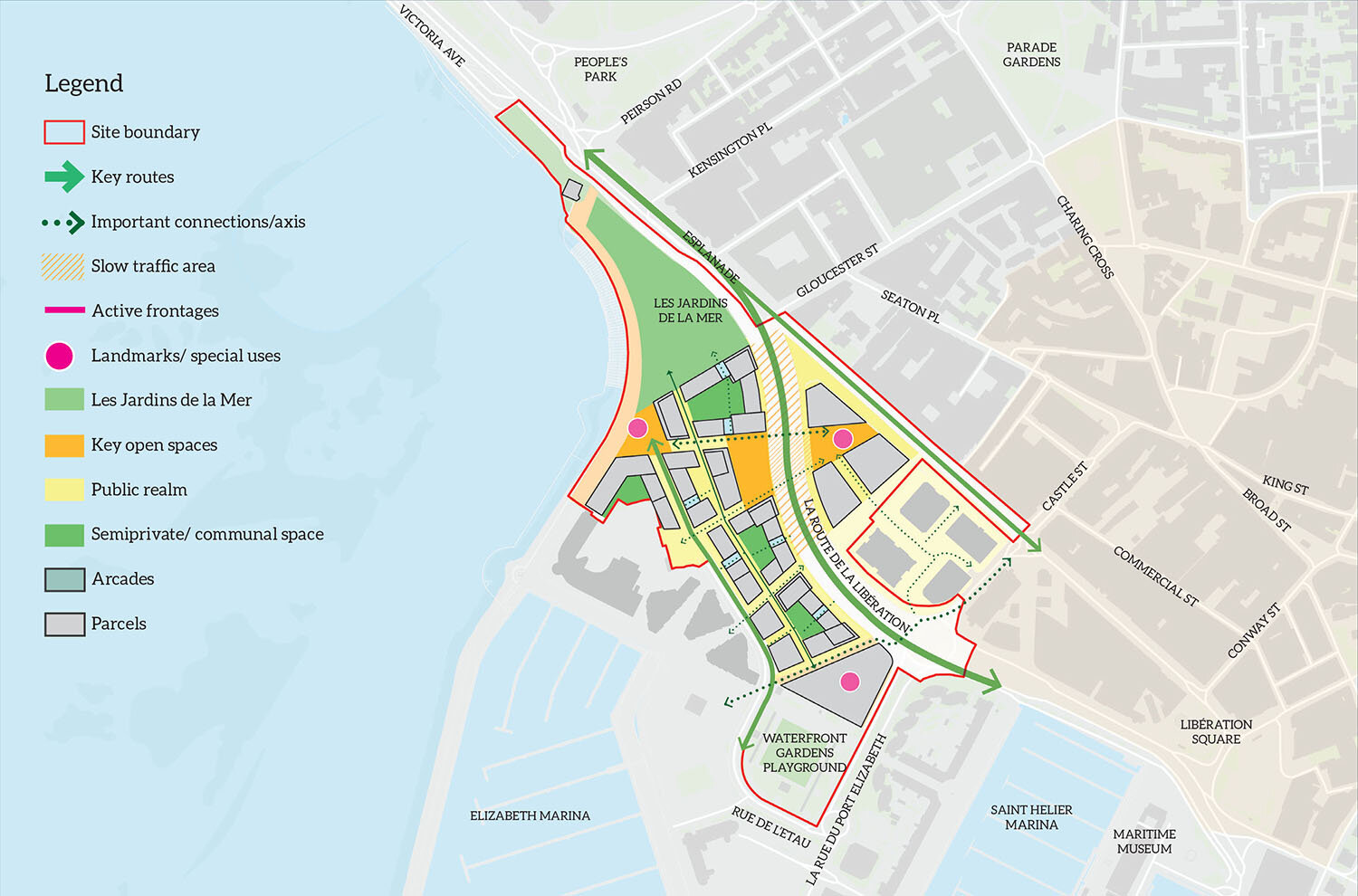
6. Framework Concept

Design Parameters & Brief
Revised Visioning Framework

Character areas

Connectivity - Pedestrian Movement
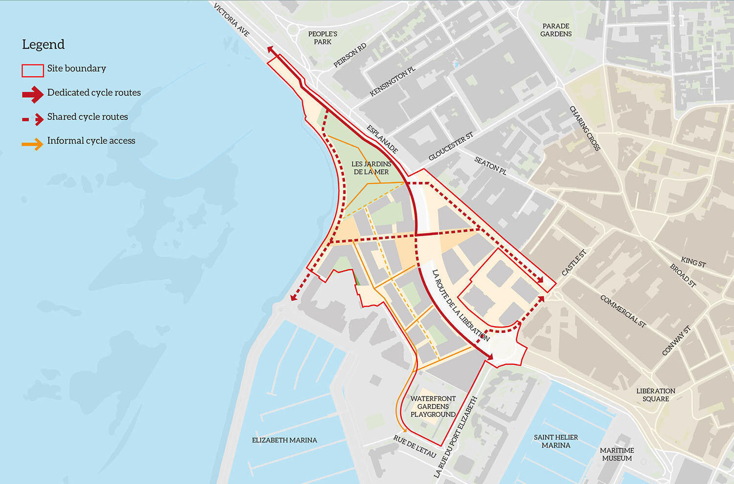
Connectivity - Cycle Movement

Connectivity - Vehicle Movement
7. Feasibility Studies: Key Findings
Traffic Study: La Route de la Libération
La Route de la Libération, known as Key Opportunity Site 7, is an integral part of the plan given the importance of improving connectivity as set out in the SPG. It serves the main east/ west route across the Island together with the Port and Town Centre.
A comprehensive traffic study has been undertaken
to review the layout of La Route de la Libération and the underpass to assess if there are ways to address the severance the road currently creates.
The study confirms that without a shift towards sustainable transport modes and significant reduction in the Island’s traffic volumes (>30%), the current provision of six lanes and underpass would need to be retained. In addition, the Island’s economic performance is reliant on a safe and efficient transport network through this area, particularly from the Port.
How can we improve La Route de la Libération?
The current concept includes interventions to address the severance and is in line with SPG guidelines, by:
Providing a new single phase pedestrian and cycle crossing between the Gloucester Street and Castle Street junctions;
Significantly improving pedestrian and cycle crossings at the Gloucester Street and Castle Street junctions
Supporting the network of new crossings with improved walking and cycle routes - fully segregated where possible;
Incorporating bus lanes/bus gates to further promote sustainable travel;
Greening and softening of the infrastructure with the inclusion of tree lined streets, verges and central median;
Reducing speeds through the pedestrian zones and
Designing the infrastructure on a human scale.
The proposals will be designed to ensure that they do not prejudice the long-term possibility of improving La Route de la Libération, or potentially downgrading it to four lanes, should there be fundamental change in travel habits.
It is however felt the cost and disruption of implementing a major intervention to downgrade La Route de la Libération would be detrimental to the Island economically and is therefore not supported by the Government of Jersey and confirms the view of the public expressed during design charettes on the planning framework during 2019.
A summary of the transport study can be downloaded here.
The decisions we take now need to ensure we can facilitate future change in social, economic and environmental demands.
Economic Study: Market Demand Analysis
The team looked at the island’s population growth, child yields and wider demographic trends, including tourism and commercial related trends, and projections and the evolving nature of the St Helier economic base to set out a market demand analysis for the development area.
This has guided us on the volume and type of non- residential uses (ground floor commercial and community uses) needed to make the area a success without impacting on the Town Centre’s viability.
The team has been mindful of the need to balance the uses, so they complement and reinforce other town centre functions, rather than detracting from it.
A summary of the Market Demand Analysis can be downloaded here.
Providing New Housing
The draft Bridging Island Plan identifies the need
for 4,000 new homes to the end of 2025. The 2019 Objective Assessment of Housing Needs calculated that based on an annual increase of 1,000 in population, 7,000 new homes would be needed by the end of 2030.
The Waterfront has a key role to play in delivering
new homes in an urban setting, in close proximity to amenities and places of work thereby reducing pressure on green-field development and reducing additional vehicle congestion during the am/pm peak hours.
The number of new homes and building heights
To meet housing need we are proposing 1,100 new homes. All homes will have private amenity space such as a balcony or terrace area.
The built form proposed varies in height and the concept sketches give an indication of the approach. This includes between 6 to 8 storeys along La Route de la Libération with higher massing allocated to the corners of blocks - up to 11* floors to bookend and create accent features in architecture. Along Rue de L’Etau the massing height reduces to 5 to 8 floors. Two new office developments proposed on KOS 1 follow the principle set by the IFC buildings and are proposed at no more than 6 floors.
In accordance with the policies outlined in the SPG document, a town gateway residential building is proposed of up to 16* storeys that will sit adjacent to the office developments.
The approach to height maximises the level of green space and access to sunlight, particularly in relation to the new landscaped areas and courtyards. Detailed solar analysis has been undertaken to inform the approach, increasing height at points where sunlight will not be affected.
* It is important to note that these heights are just proposals at this stage subject to consultation.
8. Tell Us What You Think!
Tell us what you think before we develop the proposals over the summer:
Do you support the more developed ideas for the outdoor public spaces?
Do you support the approach to improving connectivity?
Do you think we have got the mix of uses (housing, commercial and community) right?
Do you think there is enough for young people within the proposals?
Do you think the proposals complement the existing town centre offer?
What do you think about the approach to landscape design?
Do you think the approach to height is well thought through?
What do you think the key priority is for the team as we progress to a more detailed design stage?
Do you have any other comments?
Please fill in a questionnaire online to tell us what you think or email the team with your thoughts.
The deadline for comments is 3 June.
There will be further opportunities to comment in July when we will undertake another stage of consultation with the community.

La Rue de L’Etau – A vibrant tree lined street which connects to the waterfront